

The Matas "barn", Robin Plantation
St. Landry Parish, Louisiana-history and archaeology of a nineteenth century milk house
Sara Anne Hahn Louisiana State University and Agricultural and Mechanical College, 2005

St. Landry Parish, Louisiana-history and archaeology of a nineteenth century milk house
Sara Anne Hahn Louisiana State University and Agricultural and Mechanical College, 2005
Prairie des Femmes is a small prairie found near the border of the Ishak and Oplousas territory, one of the earliest places found and settled within the colonial Poste des Opelousas. My research of this place has spanned 20 years and continues to grow in profondeur. Prairie des Femmes is a translation of the original Ishak, possibly Choctaw name. In keeping with this momentum, my goal is to find the indigenous name for this land. The possible approximation provided to me by Attakapas-Ishak scholar and poet Jeffery Darensbourg is Lōksh Keshíke, Prairie Women, in Ishak, but we can not know if the French that remains is a true translation of what was originally here, or their interpretation of what they found.
Our Lady is not bound by means but if we must give boundaries she is found at the triangulation of the villages of Grand Coteau to the west, Arnaudville to the east, and Leonville to the north. The historic community of Frozard (Olivier Plantation) is found within the southern boundary of Prairie des Femmes, at an intersection of the old native path we now call Hwy. 93 and Meche-Frozard roads, and extends south to the junction of Bayous Fuselier and Bourbeux. I often say that if Prairie des Femmes had a city or crossroads, it would be Frozard.
PDF is water-bound by an oxbow swamp to the north, Bayou Fuselier to the southeast, Bayou Bourbeaux to the north and west. There are at least two bridges in the interior prairie, one over the Bourbeaux at Hickory and one over La Coulee des Marks known as Marks Bridge at Jules LaGrange.
She is a prairillon among other larger prairies of Louisiana. To the north, in the back, and across the oxbow swamp is the native-Creole enclave of Prairie Laurent, also known as la Côte/l'anse des Mulates. To the northwest, la Prairie des Coteaux where Cypress Valley can be seen east of I49 at Opelousas. To the west of Prairie des Femmes is la Prairie des Grands Coteaux, and to the east, la Pointe Claire and la Prairie des Gros Chevreuils which touches the western levees of the Atchafalaya basin and encompasses Pecaniere. To the south is la Prairie Basse, aka Prairie de Manne (colonially Prairie de la Grosse Patate), with the greater Prairie Carencro further south.
Prairie des Femmes exists in an area congruent with the boundaries of the Attakapas-Ishak tribal lands and the Opelousas tribal lands and there is much evidence of earthworks, mounds, pottery, grindstones and spear points found here. There are pre-historic mound sites that connect to Poverty Point. Despite years of modern agriculture on the prairie, these features, as well as land-memory, persist and continue to reveal themselves.
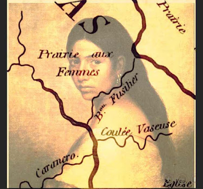
Via Mike Leblanc:
10.0 Adjacent Angles, Prairies and Points
There is yet other places, known as Prairie Laurent, Prairie des Femme, and Point Clair. Each has its distinctive character based on the stories upon which its sense of place was created.
10.1 Prairie Laurant
Prairie Laurant is also known as Prairie des Mulates, that is literally, Prairie of Mulattoes. Mulatto is in French, is called a mulâtre for men and mulâtresse for women.[1] Perhaps one of the most well known residents of La Prairie Basse is Clifton Chenier, and his brother, Cleveland, both proud black men, who are among the founders of Zydeco music. Reflecting their racial heterogeneity, their music is a hybridization of Blues, Jazz, Cajun, Country and Western, and Rhythm and Blues, played with an accordion, that quintessential French instrument, and a washboard, a folk instrument used to create African rhythms.
10.2 Prairie des Femmes
To south of Prairie Laurent, a place is still called La Prairie des Femmes (or literally Prairie of Women). If you ask an inhabitant of that place (who are mostly Cajuns) what is the origin of that place name, you will be told that all of the men were killed while on a hunting expedition in time long forgotten or during a war, particularly World War I or World War II. However, the earliest maps of the area created by Spanish indicate that the place was called the same name so the meaning has been placed mouth to ear for some 300 years, its true meaning lost to the ghosts of another time.
To the east of La Prairie des Femmes is a place called Pointe Claire, a pasture used in the spring to herd cattle upon the grasslands. As late as the 1960’s, the cattle were driven by horseback from land laid fallow in the winter months to these nearby pastures for their spring grass. These lands were first discovered by that early band of Africans who hunted deer to extinction and were later to inter-marry with Acadians who herded cattle upon those lands.
10.3 McVeigh Plantation
To the south of La Prairie Basse lies the McVeigh plantation, a place of level lands upon a prairie cleared of its high grass and where slavery was practiced in the 19th Century and later where share cropping also enslaved Afro-American, Creoles and Cajuns in a labor system meant to drive their laborers and their families into penury and serfdom meant to tie them to land as well as to enrich their land owners. Today, McVeigh Road runs down the middle of this plantation and is bordered on both sides by cane fields.
McVeigh Road comes to an end at its intersection with Louisiana Highway 31, which parallels Bayou Teche. Alongside of highway is a narrow strip of land upon, which was too narrow to farm and which was the location of the sharecropper shacks used in the early 20th Century. While the descendants of Ton Ton were free persons of color and devote Catholics, the descendants of the slaves working on the McVeigh plantation were lively Protestants, practicing within the Baptist Convention.
Information via Mike Leblanc


.jpg)


