
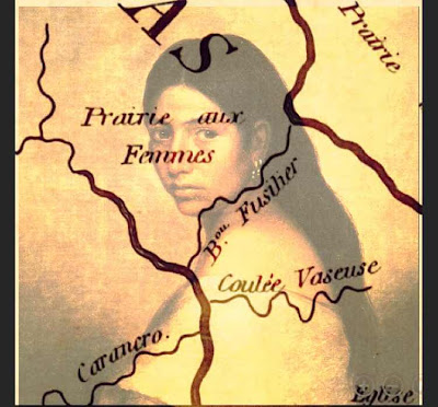
Prairie des Femmes is a small prairie found near the border of the Ishak and Oplousas territory, one of the earliest places found and settled within the colonial Poste des Opelousas. My research of this place has spanned 20 years and continues to grow in profondeur. Prairie des Femmes is a translation of the original Ishak, possibly Choctaw name. In keeping with this momentum, my goal is to find the indigenous name for this land. The possible approximation provided to me by Attakapas-Ishak scholar and poet Jeffery Darensbourg is Lōksh Keshíke, Prairie Women, in Ishak, but we can not know if the French that remains is a true translation of what was originally here, or their interpretation of what they found. Prairie des Femmes is not, as some have said, a place where indigenous women were seen "picking medicinal herbs", although this was certainly true and still is in my pasture.
Our Lady is not bound by means but if we must give boundaries she is found at the triangulation of the villages of Grand Coteau to the west, Arnaudville to the east, and Leonville to the north. The historic community of Frozard (the old Olivier Plantation) is found within the southern boundary of Prairie des Femmes, at an intersection of the old native path we now call Hwy. 93 and Meche-Frozard roads, and extends south to the junction of Bayous Fuselier and Bourbeux. I often say that if Prairie des Femmes had a city, it would be Frozard.
PDF is water-bound by an oxbow swamp to the north, Bayou Fuselier to the southeast, Bayou Bourbeaux to the north and west. There are at least two bridges in the interior prairie, one over the Bourbeaux at Hickory and one over La Coulee des Marks known as Marks Bridge at Jules LaGrange.
She is a prairillon among other larger prairies of Louisiana. To the north, in the back, and across the oxbow swamp is the native-Creole enclave of Prairie Laurent, also known as la Côte/l'anse des Mulates. To the northwest, la Prairie des Coteaux where Cypress Valley can be seen east of I49 at Opelousas. To the west of Prairie des Femmes is la Prairie des Grands Coteaux, and to the east, la Pointe Claire and la Prairie des Gros Chevreuils which touches the western levees of the Atchafayala basin. To the south is la Prairie Basse, aka Prairie de Manne (colonially Prairie de la Grosse Patate), with the greater Prairie Carencro further south.
Prairie des Femmes exists in an area congruent with the boundaries of the Attakapas-Ishak tribal lands and the Opelousas tribal lands and there is much evidence of earthworks, mounds, pottery, grindstones and spear points found here. Despite years of modern agriculture on the prairie, these features, as well as land-memory, persist and continue to reveal themselves.
No comments :
Post a Comment