Sunday, September 15, 2024

“Be Happy”


Origin of Grand Coteau

 Grand Coteau, La. 

The origin of Grand Coteau dates back to 1821, when Sieur 
Charles Smith, a large land owner in this section, donated land to 
the church for a convent. The convent was founded by Mother Eugenie. 
Aude and called “Grand Coteau.” In 1837 St. Charles College was 
built. The settlement that grew up around the two schools was 
originally called “St. Charles Town,” but later became known | as 
Grand Coteau, the name it still holds today. 

Opelousas Place Name

Some origin stories I have heard about Opelousas name:

1.  It was briefly mentioned to me once a long time ago that someone said they heard it was believed it is from "la pelouse" (the lawn in French). I don't think this is a correct origin, but is an interesting view onto the French lens applied to native named things in Louisiana (think sac-a-lait). I only mention it for thoroughness, because everyone knows Opelousas is a native place. 

2. Opelousas is known to be a native place, named for the tribe of Ishak who called                 themselves or their place Opelousas (black leg).

            a. black leg because - the natives walked the tea colored swamp water (Leonard             swamp) and other bayous. The tannins in the water made their legs dark.

        b. black leg because the natives had dark skin

        c. black leg because the natives walked the burned prairies and the soot made                         their legs  black

        d. black leg referring to salt water?
        
        e. vpi lusa /black stem  (oppaloosa) - aster. This is also known as the Symphyotrichum lanceolatum /panicled aster.  The Choctaw name for it is vpi lusa (black stem).  The elder who brought the plant told me that it's where he believed the name Opelousas. Unsure if this is passed down information or based on similarity of the name. 
                                               information relayed from Dr. Ian Tompson of the Choctaw                                                     Nation of  Oklaholma
                                                                                    -through Dustin Fuqua

 photo Pete Gregory


INFORMATION From Some History of Saint Landry Parish from 1690's By RUTH ROBERTSON FONTENOT

*Note Attakapas-Ishak is the preferred name of the tribe today, and

 One hundred and fifty years ago April 10, 1805, St. Landry Parish was officially established by an act of legislature. In 1690 the first white man is believed to have settled in Opelousas, which is the parish seat, thus making Opelousas one of the oldest settlements in these United States, The name of the first settler has not come down to us, but he was undoubtedly a Frenchman. The Attakapas Indians were here - this was their land, They had chosen for their camping grounds the site of the city of Opelousas, because of its location on high land above the flood level. From legends comes the story of how Opelousas was named. The Attakapas were {RUMORED TO BE} a cannabalistic tribe, fierce and warlike, and they: preyed upon the neighboring tribes who dwelled along the high bluff that we call the Grand Coteau ridge. There were three tribes - the Opelousas, the Choctaws, and the Alabamans. They held a counsel and decided to try and wipe out the Attakapas, who were constantly making war with them. So together the three tribes waged war upon the Attakapas and finally succeeded in driving them from their lands, destroying almost the entire tribe of Attakapas Indians. The few who escaped with their lives flew to the south, and made their camping-grounds in the regions of what is now St, Martin parish. The three tribes then made a pact and gave the land of the Attakapas to the Opelousas Indians, and thereafter the territory was called ‘‘Opelousas”’, as the land below it was cal= led “Attakapas"’. ‘For their main campsite the Opelousas tribe chose the high land on which the present city of Opelousas is located. The exact spot has by tradition been established as the grounds of the old Academy of the Immaculate Conception, on the north end of town. Some years past there was here a small mound with a pine tree Standing on it, and this was said to be the lookout post. Many arrowheads have been turned up on lands nearby, and also fear this same spot are some very old springs. The name “‘Opelousas’ has been given many meanings, but the one most commonly accepted is ‘‘Blackleg’’ -- possibly the tribe painted their legs a dark color. Other trans- Tations are “Blackfoot’’, and ‘‘Man with black leg’’. Still another translation is ‘‘Salt Water,’’ which alludes to the fact that from here south the land lowers to the Gulf of Mex- ico and ‘‘saltwater’’,

Olivier Plantation

 OLIVIER PLANTATION HOUSE on Bayou Bourbeaux in Prairie des Femmes, as viewed here, shows it to have been a typical river plantation house that was similar to those built by most of the early French settlers in Louisiana. The view is-from.the rear and shows the carriage entrance. A pigeoniere stands oneither side of the house. The present Olivier home, which is also a very old one, is said to have been moved out to its present location from the town of Grand Coteau. All of these old photographs loaned to us by the Oliviers are of especial interest in that they are arranged for viewing with a stereoscope, which makes the pictures thus seen three-dimensional -and very sharp and clear although they are yellowed with age. 


KING COTTON Goes To J & W SIBILLE CO. In Sunset 


Saturday, September 14, 2024

Prairie Des Femmes Water Corporation


Prairie Des Femmes Water Corporation constructs and operates a water distribution system within and for that part of the area within the confines of St. Martin Parish lying within the following area:

Beginning at a point which is the confluence of Bayou Carencro, Bayou Fuselier and the Vermilion River; said point also being the common boundary of St. Landry Parish, St. Martin Parish and Lafayette Parish; thence following the meanderings of Bayou Fuselier in a northerly direction to its intersection with Bayou Bourbeaux; thence following the meanderings of Bayou Bourbeaux in a northwesterly direction to its intersection with the centerline of Louisiana Highway 93; thence in a westerly direction along the centerline of Louisiana Highway 93, a distance of 5,400 feet; thence in a due north direction for a distance of 7,000 feet to Bayou Bourbeaux; thence following the meanderings of Bayou Bourbeaux in a northwesterly direction to its intersection with Coulee de Marks; thence following the meanderings of Coulee de Marks in an easterly than a south-easterly direction to its intersection with Bayou Fuselier; thence following the meanderings of Bayou Fuselier in a south-easterly direction to its intersection with the western corporate limits of the Town of Arnaudville; thence southerly along the western corporate limits line and a projection thereof to the intersection with the centerline of Bayou Pont Brule; thence following the meanderings of Bayou Pont Brule in a southwestern then southerly direction to its intersection with the Lafayette Parish-St. Martin Parish Line; thence westerly along said parish boundary line to its intersection with the centerline of the Vermilion River; thence following the meanderings of the Vermilion River in a north-westerly direction to its intersection with Bayou Carencro and Bayou Fuselier which is the point of beginning.

Write up from Botanica

Life Everlasting | Pseudognaphalium obtusifolium

Ashlee Wilson, 2024

Installation


In "Café des Exiles," George Washington Cable reports,

"An antiquated story-and-a-half Creole cottage sitting right down on the banquette, as do the Choctaw (women) who sell bay and sassafras and life-everlasting."


What was this old herb the Choctaw women sold while sitting on the banquette in New Orleans? Used by traiteurs in down the bayou communities for centuries, life everlasting known also as fragrant rabbit tobacco and vinéraire is revered for her healing properties, as well as a distinct syrup smell. Indigenous people of this land used her as a sweat lodge and funerary herb, smudge, lung and skin healer, as well as psychological aid. She is a spirit plant and integral part of smoking blends of the Americas. In Creole culture, she was used as a remedy for fever.

Living in southwest Louisiana, I was told that vinéraire was a "lost" plant, her absence a sign of the impact of saltwater intrusion and habitat destruction. But in 2011, a patch appeared at my home, Prairie des Femmes (Prairie of the Women), in St. Landry Parish. I first realized vinéraire was growing by smelling its fragrance. I often say she's smart like a chaoui (racoon). If you leave food out and make a habitat for it, she will follow you around. A mid-successional species, she can appear when a prairie begins to heal, coming back to its original vitality. The quest to identify and grow her has given me what feels like a secret wink from the universe.

From the first three volunteer plants, there are now over 200. I celebrated every new plant, complimented her, called her "darling," manicured the caterpillars, cleared the weeds and protected her from poison as well as from man's cruel blade. The plants multiplied and they got bigger. In addition to making medicines, I save the seeds and share them with native women, and all those who need it, in an effort to return this important healing herb to the land and people of south Louisiana. 


edited by Rachel Breunlin


The Prairie Has a Memory Ashlee Wilson, 2024


Ashlee Wilson is a Ville Platte native and self-taught Louisiana French speaker. She is a teacher and artist known for her writing, photography and visual journals that document her acquisition of Louisiana French, as well as native plants and folk herbalism. She is the creator of the Prairie des Femmes blog (2012), an online space that documents this historical prairie's daily life, as well as The Plains of Mary (2014) and the Ô Malheureuse collection (2019 UL Press). She teaches French at the Academy of the Sacred Heart at Grand Coteau.

The Prairie Has a Memory is an homage to her home, La Prairie des Femmes (Prairie of the Women), in St. Landry Parish. Found in records since the mid to late eighteenth century, the land is located in an area of high native traffic near the boundaries of the Attakapas-Ishak and Opelousas territories, just east of the sacred hills of Grand Coteau. A former sweet potato farm, for more than twenty years, Ashlee has cultivated plants and knowledge of the prairie with her family as an act of restoration- planting native species, and implementing a plan to minimally mow, periodically burn, and forgo poison on the land.


La Pointe Claire

General belief is that Pointe Claire was a clear, open grassland in the cove directly east and bordering la Prairie des Femmes. To arrive at the Pointe Claire from the Prairie des Femmes cross the Coulee des Marks at Marks Bridge, and travel north on Jules LaGrange until it intersects Hwy 347. To the west one will intersect Leonville and the Bayou Têche, and to the east toward Arnaudville is la Pointe Claire. 

Sunday, September 8, 2024

The Protection of the Academy


The Grand Coteau was high holy ground before the Jesuits settled it for Catholic formation of their religious and then the religious of the Sacred Heart. There is an oral history that says it was there native men went to fight with honor. At the westernmost ridge of the old Mississippi River, and near the tribal boundary of the Attakapas-Ishak and Opelousas, this seems plausible.  The elevation alone made this land some of the finest and safest around. Grand Coteau is found at the uppermost limits of the Prairie Carencro, on land on the Teche Ridge that was also called Prairie des Grands Coteaux.  Despite some overlap in orientation, both topographically and culturally, the Grand Coteau is singular and known as holy land in south Louisiana folklore. 

The prairies, ridges, swamps and coves of south Louisiana overlap and interplay.  The edges of the Prairie des Femmes have a liminal quality that matches her landscape and they mystery of the women's protection she provides. Grand Coteau is the high ridge directly east and adjacent to Prairie des Femmes, and the same stretch of Bayou Bourbeaux that acts as PDF's western limit also runs through the Academy of the Sacred Heart at Grand Coteau's realm, less than a half mile from the school. No place is closer to the Praire des Femmes both physically and spiritually, as Grand Coteau, as they share this history of being a mystical place of women's protection. The Academy is the second oldest institution of learning west of the Mississippi River and also the site of a shrine to Saint John Berchman, who appeared there to novice Mary Wilson and healed her through his intercession. This is the reason the Academy is the only place where a recognized miracle took place in North America.  Today as I write, the shrine sits directly above my classroom. 

The Academy served as a safe haven for women and children through the Civil War. The school was protected by the Union and instruction of the girls never ceased. Because of this protection, within the Sacred Heart, and also due to the communication of industrious women, it was not burned, and the Academy and town of Grand Coteau stand still in operation today. 

The convent of the Sacred Heart was founded in Grand Coteau in 1821 by the Religious of the Sacred Heart and had five students that year. In 1861 the Civil War's skirmishes around Bayou Bourbeaux (Battle of Buzard's Prairie at Chretien Point and east along the bayou) were audible from the school and the nuns reported seeing the battle from the third floor gallery. They began to fear for the school and the girls' safety. 

In 1862 General Nathaniel Prentice Banks became the commander of the Department of the Gulf. He and his wife Mary Theodosia Palmer Banks had a daughter in a Sacred Heart school at Manhattanville, New York.
The following is correspondence between Mother Jouve and General Banks concerning the protection of the Academy: 

Notes from Reverend Mother Jouve, July 1864


Thanks to the protection of the generals, or rather to the Heart of Jesus, our property has been respected, and guards have been sent by the officers to protect us from the marauders who infest the area. For more than two months, we heard the noise of the cannons; some of the skirmishes took place on the road which leads to the convent, and from our gallery we were able to follow the phases of a real battle between the Confederate guerillas and the Federal troops.

In these moments of crisis, prayer was constantly our recourse, the Way of the Cross, adoration all day and the Holy Hour at night, the most exact practice of the Rule. Finally, the certitude that our Mothers and Sisters were praying for us, all combined to sustain our courage, and to help us to live through this time of trial with calm and confidence."
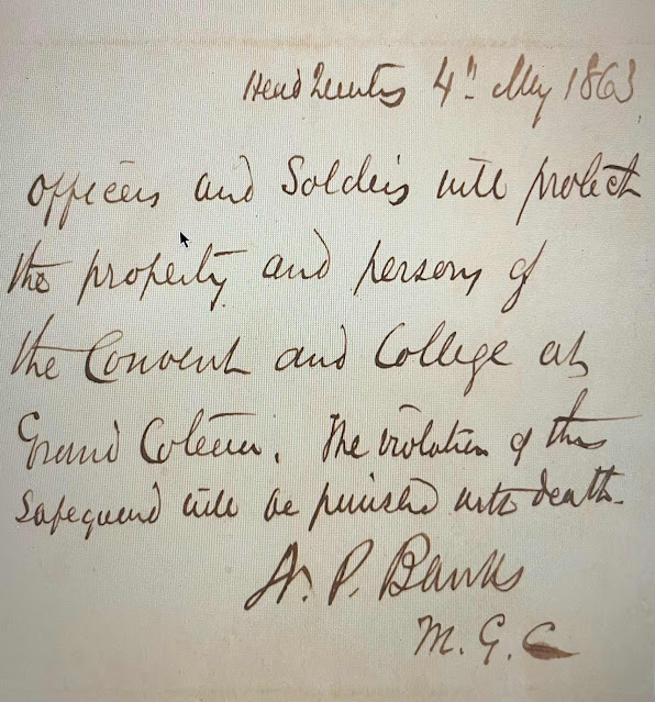


20 April 1863

To the Superior of the Convent of the Sacred Heart-

If you desire to send letters to New York, you will please forward them to me by the bearer who is instructed to wait for them. I send a safeguard that will protect your school from the stragglers in the rear of my column and if you desire it will leave a guard. I regret that I cannot call to see you. My daughter is with Madame Hardey at New York.

Mrs. Banks who visited the school but a short time since writes that all are well there.

I am respectfully your obt servant,

N.P. Banks


*Mary Aloysia Hardy ppt compiled by Caroline Richard 2020


The Union did not only protect the Academy with stationed guards, but provided the sisters and the girls food and bolts of fabric for new clothes.  As far as oral histories of Prairie des Femmes go, the most available in the mind of the people is the one owes the name to the Civil War. Though the name is older than the war, and probably refers to some native wars also, I often wonder if reports of forts and extreme refuge found here rest in the power of the memory of the protection of the women and children of the Convent of the Sacred Heart at Grand Coteau under penalty of death.


Saturday, September 7, 2024

Our Lady is not Bound by Means: The Borders of Prairie des Femmes

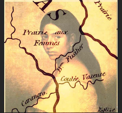
 Prairie des Femmes is a small prairie found within the colonial Poste des Opelousas. Our Lady is not bound by means but if we must give boundaries she is found at the triangulation of the villages of Grand Coteau to the west, Arnaudville to the east, and Leonville to the north. The historic community of Frozard (the old Olivier Plantation) is found within the southern boundary of Prairie des Femmes, at an intersection of the old native path we now call Hwy. 93 and Meche-Frozard roads, and extends south to the junction of Bayous Fuselier and Bourbeux.  She is water-bound by an oxbow swamp to the north, Bayou Fuselier to the southeast, Bayou Bourbeaux to the north and west. There are at least two bridges in the interior prairie, one over the Bourbeaux at Hickory and one over La Coulee des Marks known as Marks Bridge at Jules LaGrange. 

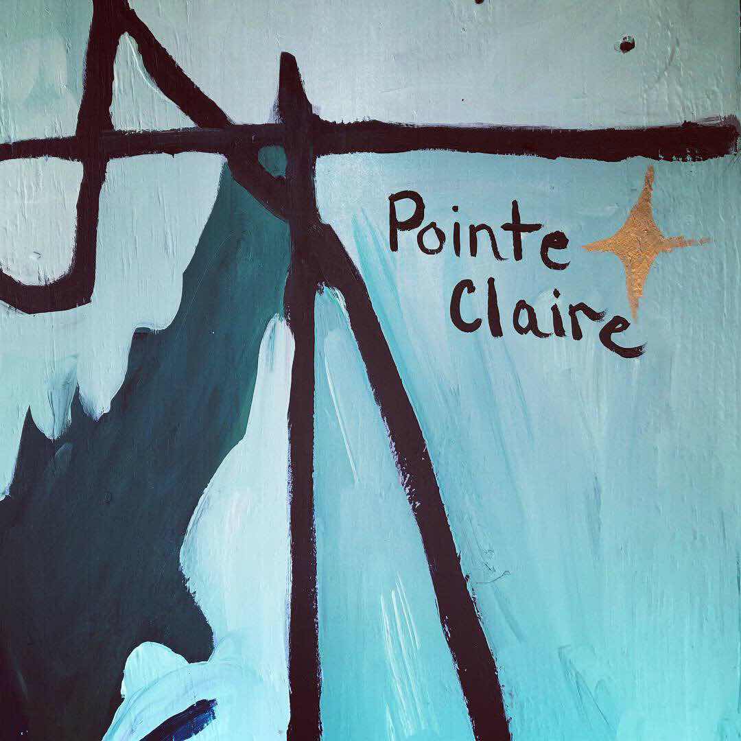
She is a prairillon among other larger prairies of Louisiana. To the north, in the back, and across the oxbow swamp is the native-Creole enclave of Prairie Laurent, also known as la Côte/l'anse des Mulates. To the northwest, la Prairie des Coteaux where Cypress Valley can be seen east of I49 at Opelousas. To the west of Prairie des Femmes is la Prairie des Grands Coteaux, and to the east, la Pointe Claire and la Prairie des Gros Chevreuils which touches the western levees of the Atchafayala basin. To the south is la Prairie Basse, aka Prairie de Manne (colonially Prairie de la Grosse Patate), with the greater Prairie Carencro further south.

Prairie des Femmes exists in an area congruent with the boundaries of the Attakapas-Ishak tribal lands and the Opelousas tribal lands and there is much evidence of earthworks, pottery, grindstones and spear points found here. Despite years of modern agriculture on the prairie, these features, as well as land-memory, persist and continue to reveal themselves.  


Tuesday, September 3, 2024

Prairie des Femmes Origin Stories

 Prairie des Femmes

Coming to the Prairie and Staying


When I arrived here in 2004 my neighbors called the area Leonville or Anaudville, for the bayou villages to the extreme north and east of the prairie, respectively. There was no marker, no sign and no online presence of the pre-colonial Prairie des Femmes, save for topographical maps where she was marked at Coulee des Marks bridge, and two inquisitive articles published in the Teche News by Mr. Floyd Knott.  If I am completely honest, there was also a wood routed sign that said Prairie des Femmes on a neighbor's chicken coop up by the Bayou Bourbeux that I spied through the trees.  

 The romance of the name seemed to me incongruent with the general knowledge of her existence. I was from another village, called la Ville Platte further to the north in Evangeline Parish. Around la Ville we had many other lieu-dits, les petits places, where we visited and that were part of the common vernacular of life. There was Chataignier, of course, and halfway there, la Pointe Bleue and L'anse Aux Pailles. We frequented Faubourg, Tate Cove, L'anse des Belaire, Vidrine, Redell, and L'anse Grise beyond. I was familiar with these places, yet just 20 minutes from my hometown, I had moved to this women's place whose history and terrain felt remote and largely unexplored. 

Louisiana French connected me more closely to my state, her French and native memory and my place within it all. I began to gather maps, records and historical research as well as personal stories about how the prairie was named: her origin stories. It was clear that these are all native lands and la Prairie des Femmes is a reminder. The neighbors reported the prairie was a place where women and children were found living when the men left for one reason or another. If I asked, they pointed me to the Civil War as origin of the mens' absence, but the records I found suggested that the prairie had a longer memory.

  One local said he believed that the girls outnumbered the boys at the house dances, and that the Stelly, Marks and Quebedaux families produced them. Another story says that in Louisiana's historic flood of 1927 woman and children were sent here from neighboring communities because of its relative safety. (The prairie is at some elevation, but I am still not sure what parts of her flooded in '27) Another tale sites the area as a place where the widows of the soldiers of the Civil War settled to live the remainder of their lives in peace. Some say the women of the area refuged back here when the skirmishes along the bayou Bourbeaux, at Grand Coteau and Chretien Point made it unsafe for the women and children in town. Some reported that the women were left here to farm while the men fought for the Civil War, WW1 or WW2. Some locals even pronounce it "prairie des fermes" and will connect the name to the women farming, or the fact that there are still many agricultural fields here. Another neighbor gave me the rough coordinates of a "fort" that existed here for the protection of the women. 

The most likely story of the origin of the name Prairie des Femmes is the native one, of course. The prairie is a pre-colonial, native place, located at the historical boundary of the Attakapas-Iskah and Opelousas tribal lands. It is named for bands of Ishak and earlier Tchefuncte people who used the prairie was a backwater refuge for their women and children away from the major rivers and bayous of the time. Prairie des/aux Femmes appears on detailed maps of the region as early as 1806. Because of the prairie's central and borderland location, there was much native traffic and infrastructure here. 

Legend has that the area was a high land, a safe zone near the bayous where women lived together while the men hunted or warred. There are a few versions of this story. One is that the male natives inhabiting the prairie moved after a hunt, as was custom. A few of the women stayed at the camp, being too comfortable to move.  Another version says that the prairie was used in ancient times as an off-river refuge for the women that protected them until the men came back. The men were always leaving for war or hunting in the stories. Another says that the male hunters, or bears, went on a hunt leaving their wives on the prairie. The women left there were discovered by the French Creoles and Acadians (Michel Cormier) who settled the area and called it la Prairie aux Femmes. (In Louisiana vernacular the contraction des and aux are both used when showing possession, aux being older in my mind. I have found both des and aux on maps of the prairie) I am often curious if the name is a direct translation of the indigenous name for the place, and if so what the old name was. One of my neighbors had his explanation, offering "that's an old name, yeah." After 20 years of research, this seems to be the most accurate detail of all.